Introduction
Skerries Cycling Initiative is a committee of the Skerries Community Association and a member of Cyclist.ie, the national cycling advocacy network. We welcome the Greenway development as a means of improving active travel in the area and encouraging modal shift.
This Greenway will also benefit the people of Fingal by providing them with superb recreation choices, commuter cycling opportunities and jobs through tourism. Increased cycling and walking will also bring physical and mental health benefits for the people of Fingal, with potential to reduce greenhouse gas emissions.
Skerries town
In relation to Skerries town concerns have been raised by many about the route options within the town. All four options pass through Hoar Rock, Quay St. along Harbour Road and around Red Island and South Strand. On Red Island and South Strand the route options propose following the existing off-road walking paths. No other options are offered and this is a major drawback to arriving at a route that can work for residents and potential users.
We feel strongly that the creation of an amenity for cycling and walking visitors should not involve the loss of amenity for residents of the town.
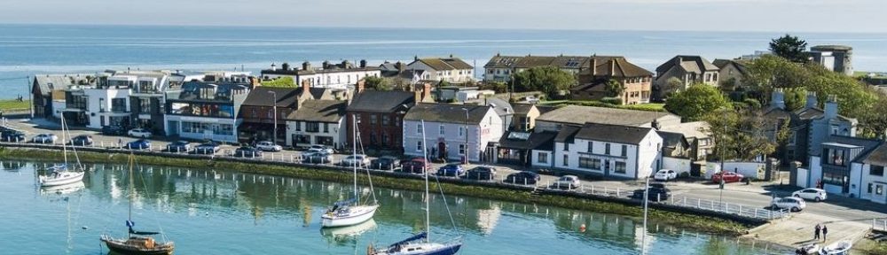
Red Island and South Strand
Red Island and South Strand have for many years formed a continuous section of a Slí na Sláinte (Healthy Way) walking route, an amenity treasured and enjoyed by locals and visitors. It is generally considered unsuitable for cyclists other than young children cycling under supervision. It would be best to retain it as a place for exploring on foot and we would therefore recommend that secure bike parking and lockers (for cyclists who are travelling with luggage) be provided on both the north and south access points.
Similarly the South Strand pathway is also heavily used by pedestrians including people using mobility aids and people walking dogs, often with extendible leads. Cycling was banned here some years ago for safety reasons. Widening the existing path to make it a shared pedestrian/cycle path would present huge design challenges and could lead to conflicts between users and possibly lead to a loss of amenity for non-cycling users while also making cycling difficult and uncomfortable. At busy times it could require a “cyclists dismount” regime in the interests of public safety.
On-road cycling safety on Harbour Road and South Strand Road could be improved through traffic calming and signage to make cycling there safer. However if it is to be suitable for cyclists of all ages and abilities segregation from motorised traffic would be needed. As a fallback option to segregated on-road cycling a segregated track parallel to the current walking path is the only practicable option to ensure public safety. This should have regard to the sensitive nature of the location and be constructed from sustainable, environmentally friendly materials.
Just before the junction of South Strand Road and Harbour Road there may be scope to provide a short segregated path from roughly opposite Bob’s Casino along the grass stretch which runs behind the houses along Harbour Road. This would give cyclists who wished to avoid Harbour Road an off-road path between the ramped path to Red Island and the and South Strand at Bob’s Casino. Hoar Rock and Quay Street.
Both of these residential areas are currently used by local walkers and cyclists. “Rat running” continues to be a problem and if a way of limiting motorised traffic to local access only it could improve things for residents. As matters stand it is not supported by residents as a route for additional pedestrian and cycle traffic and a solution acceptable to them needs to be arrived at and their buy in would be required to any new traffic management arrangements being considered.
Active travel network needed in the town
Rather than channelling all cyclists, whether they wished to visit or simply pass through Skerries, into the busiest harbour and coastal zones it may be more practicable to have the main cycle route skirt the busiest areas but to enable access to the town centre via different spurs from that main cycle route.
Skerries Cycling Initiative is advocating for a mobility plan for Skerries which will encourage increased cycling and walking, and less congestion. This planning process should work in tandem with the greenway designs for the town.
Alternative routing through town.
Given that the four routes appear to be presenting difficulties for various reasons:
(residents objections in Hoar Rock and Quay St., and loss of amenity to users of Red Island and South Strand walking paths), other means of navigating the town may need to be considered.
Improving cycling and walking within the town should be done before the greenway arrives at Skerries so that safe, suitable routes exist in the town for cyclists following the greenway to take wherever they wish to go in the town.
This approach should take advantage of:
- the location of the train station at the western side of the town with its potential for bringing cyclists to and from the greenway.
- The existence of a wide 2 km green verge in public ownership linking the train station to Skerries Point along the Barnageeragh Road.
The following comments follow the sequence of diagrams presented by FCC, starting at the Meath border.
Balbriggan Route Option : SS2D
All the routes are acceptable. The Red route which diverts more towards the coast but the other route options would also have unobstructed sea views.
Balbriggan Route Option : SS2C (Balbriggan town)
Further to the south, an issue arises as to whether to go east of Fancourt
Heights/Hampton Cove or straight down the R127 (orange line, favouring commuter cycling out of Balbriggan). The eastern coastal lines (red, green blue,yellow) pass through a beautiful coastal site and seem the obvious choice. The short orange route might also be possible, as an addition favouring commuter cycling needs. While the pink line through the centre of the town is not acceptable as the Greenway, it should be part of the cycling revitalisation of Balbriggan and it provides an exit southwards from the town via Castlelands, as shown in SS2B below.
Balbriggan Route Option : SS2B
The key issue here is whether to go very coastal (red line), or basically along the R127 on the seaward side (Green and Blue lines). Bearing in mind that Green/Blue still have unobstructed views of the nearby sea, then the over-riding factor of providing a direct route between Balbriggan and Skerries which will serve utility cyclists well, wins out (Green & Blue). The Skerries Cycling Initiative has been campaigning for a proper segregated cycle track between these two towns since its inception in 2007. If only the Red route is provided, commuter cyclists will not use it and they will remain on the R127, probably to the chagrin of motorised traffic drivers.
Two other key issues are :
- The importance of the link shown to Castlelands (blue line), which provides direct access to the centre of Balbriggan town.
- The need for a high-quality access point to Ardgillan Demesne. Currently the bridge at Ladys Stairs is physically demanding for those wishing to bring their bicycles into the park (where a recreational cycling circuit was laid out about 10 years ago with the cooperation of the Skerries Cycling Initiative). Is a fenced route possible under the railway bridge and immediate right towards Ardgillan that does not infringe on private property? In 2005, FCC staged an evening performance of the band REM in Ardgillan Demesne. On that occasion, attendees from Skerries and Balbriggan on foot were ushered into Ardgillan via such a route starting behind at the railway bridge.
Skerries Route Option SS2A
This section matches the importance of SS2C in that it passes through Skerries town and it will present significant engineering challenges. However it is important to emphasise that Irish Greenways and indeed, in Europe generally, reach towns, i.e. towns are destinations, rather than going through them on specifically created infrastructure. Physical disruption or infrastructural change should be kept to a minimum. This applies to Balbriggan and Donabate as well.
The following are some issues that arise :
- The Red route is the only fully coastal route. Currently there is no complete footpath from Skerries town to Barnageeragh (and Ardgillan Demesne) and the Greenway would provide that. The major problem with it will be getting through a narrow winding section of road between Barnageeragh railway bridge and the new junction with Barnageeragh Road where large vehicles have difficulty passing each other. It might be possible to widen the road, making space for a Greenway. Alternatively, the narrow winding section could be managed in a one-way fashion with alternating red and green traffic lights but traffic delays would ensue. Whether to widen the road or create an off-road boardwalk solution are options to be considered.
- The Yellow route shares the narrow winding section with the Red Route but continues straight on at the junction with the Barnageeragh Road and returns to the R127 via Kelly’s Lane. It has the merit of utilising an existing cycle track on the Barnageeragh Road but it misses out on a beautiful section of the coast road (R127, Red route) and that makes it hard to justify.
- The Green & Blue routes are variations on a strategy to take cyclists from the railway bridge area up a hill to a location adjacent to the rail line where they run parallel to the line before descending to rejoin the other coastal route options. They have a major merit of eliminating the difficulties associated with the narrow winding section but again, they miss out on sections of attractive coast. The steepness of a gradient that cyclists might have to undertake with the Green/Blue options would have to be addressed
e.g. by a cyclist/pedestrian bridge parallel to the existing railway bridge, that would descend with a gentle slope to the railway side of the R127. The Greenway users would need a safe crossing of the R127 to reach the cycle track on the eastern side of the R127.